
Gbésè, GbÉbodi in karijini
Our morning at the caravan camp started with a banter with Lyn and Ray (surname withheld), as we packed up the Explorer in preparation for the day’s trip. They had come around to spread some clothes on the line and we had exchanged pleasantries that started our conversation.
When Ray asked me where I came from, originally? I took him to the side of the Explorer where I have the map of Nigeria, coloured in Green, White, and Green (the Nigerian Flag colours) pasted on the fuel tank cover and asked him to guess. Spot on, I said, as he mentioned Nigeria. He was the first person out of about ten that had passed this test of identifying the Nigerian map. I have had answers ranging from Kenya to Zambia from various others which informed my position that many Australians know next to nothing about Nigeria. Of course that itself is not surprising considering that this is a country where the minister of education, Dan Tehan, refers to Africa as a country! Little wonder that I immediately concluded that they were not Aussies.
Lyn and Ray turned out to be South African whites that fled South Africa in the wake of the post-apartheid elections. They were concerned about possible retributory attacks from a black dominated government. From their looks, they would pass for an Aussie any day but they still identify themselves as Africans, that is, despite having spent more than two decades here in Australia. In fact, Ray informed that he constantly makes trips back to South Africa and feels more at home there than here. While they love the amazing scenery and the security that Australia offers, home is still South Africa and that is where their hearts are. When probed further, they explained that Australia is a lovely country that promotes diversity and supports immigrants to keep their ethnic identities but the average Australian is not very tolerant of immigrants.
Probably to endear themselves to us, Lyn shared her experience in having to host a Nigerian college kid during the Covid19 pandemic. On mentioning the lad’s name, we were pleasantly surprised to realise that he is the son of a family friend. Life has a way of bringing up unexpected coincidences, the reason why we need to maintain a good name at all times in all situations.
With Lynn and Ray gone and the Explorer loaded up, we decided to do a little exploration of the town by hiking to the top of Tank Hill. The hill is right at the back of our camp and hosts an enormous water tank with the bold inscription “Welcome to Marble Bar” and another saying “Our summer is Hot, Our Winter is Warm and Water is Precious.” We ascended the mountain following a bush path strewn with small, jagged rocks and had to keep our eyes on the pathway in order not to miss our steps and fall. It was a strenuous effort to cover the short ascent as it was rough sloppy and overgrown with weeds.
At the top of the hill, our effort was rewarded with a beautiful view of the town as it spreads flat down below us. We could see the well laid out streets in form of a rectangular grid, the maintenance offices of a few mining interests and the rolling hills in the far distance that surround the town, holding it in their belly. The voice of my geography teacher echoed in my ears asking me to look closely at the hills and explain why Marble Bar is sited here. There you go again, Seun, you got it wrong. Have you considered how the surrounding mountains could have contributed? No ma. Okay then, haven’t I taught you about the defence from invaders that hills offer? She asked me to remember the examples she had given about Idanre, a similar city in Western Nigeria surrounded by hills. I smiled. It was as if I was in her class again, while teaching us about factors for the location of cities. I wanted to raise my hands and tell her that I don’t think this was the reason for the choice of this location to site Marble Bar in the late 1800’s
As it happened, she was’nt completely wrong. We came to learn of the existence of an old airfield here, the Corunna Downs, just 35kms south of the town. It was a secret airfield located in this scrub and spinifex country from where the American and Australian Air Force units operated during WW2, carrying out numerous bombing raids on Japanese bases and shipping. The choice of this location was simply due to the protection from detection from enemy aircrafts that the mountain ranges offer.
Departing Marble Bar, we made a brief stop at the Community Resource Centre in the heart of the town, almost directly opposite the Ironclad Hotel. We needed some internet connection to communicate with our home team about our plans for the day. Surprisingly, even in this remote location, it was available and free! I was impressed with the policy intent of the Australian Government in extending services to the outermost reaches of its citizenry, especially the first nation people. As we entered the centre, we saw a mid-aged Aborigine Woman undergoing Adult Education in the English Language, a confirmation that the education system doesn’t want anyone to be left behind. This scene brought up memories of the similar program promoted by the Nigerian Military Government in the late eighties aimed at improving adult literacy and the rural education of many Nigerians. The program was initially popular but the policy was not continued by succeeding government and it died leaving still many Nigerians in need of basic education.
There are two gas stations in Marble Bar, one each at the beginning and end of the town, depending on wherr one enters or exit the town. Prior to leaving, we headed to the gas station to top up our fuel, the price was exorbitant. With no options, we swallowed our pride and bought it, the Explorer being a thirsty vehicle that won’t blink an eyelid before abandoning us in the cruel summer heat of the outback if it runs out of fuel.
As we drove out of Marble Bar, to get to Karijini, we either go all the way back to Port Hedland and from there join the Great Northern Highway heading south, all on good tarred roads or follow the Hillside Road. The Hillside road will reduce our commute distance by about 202kms but is a track road for at least 51 km before we can get on any sealed road. Presented with an opportunity to put the Explorer to do what it is built for, we chose to follow the Hillside road.
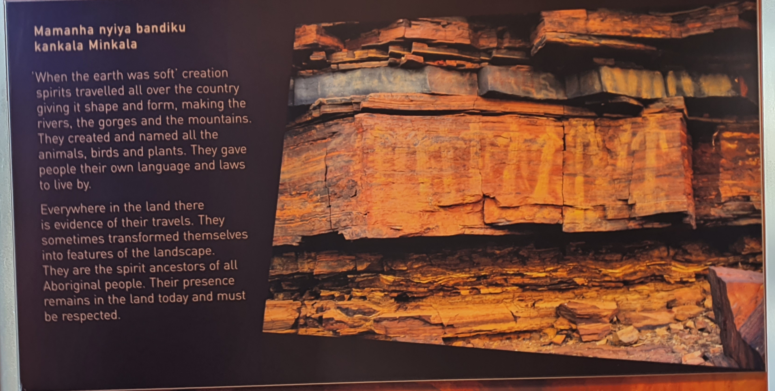
Mount Nameless was not on our itinerary but as we drove out of Marble Bar, our attention was drawn to the name somehow but can’t remember how. The name awoken a curiosity in us, how can a mountain be nameless to be called exactly that? For the settling Europeans not to find a name worthy to call the mountain, to us, smirks of dis-ingenuity. As we were later to learn, when we arrived att the Karijini Visitor’s Centre, our thoughts were in agreement with the thinking of the Aboriginals that own these lands for centuries. There, on a display, were the words of Lola Young, a Yinhawangka (the Aborigine group in this area) Elder regarding the Europeans naming of Mount Nameless:
“I think there is a lot that non-Aboriginal people could learn from Aboriginal people. You know, the non-Aboriginal people named the biggest hill around here at Tom Price, Mount Nameless. They didn’t ask the Aboriginal people here if that place had a name already. And it had. Its name for thousands of years has been Jarndunmunha: there’s nothing nameless about that. I think it is a matter of respect of cultures.”
A little on the outskirts of Marble Bar, heading south-westward we were brought to a halt by an ongoing gold mining operation. Under the disguise of safety, which we interpreted as effort to prevent gold scavengers from messing around here, we had to wait until an escort vehicle was made available to escort us through the operation. This area with its ancient landscapes; the red earth; and its vast mineral deposits is truly the bread basket of Western Australia. In some places, the track hugs closely the sides of ageless mountains and we were tempted a few times, but for lack of time, to alight from the Explorer and walk to their tops. Looking at these mountains, one needs little convincing to agree that these hold tremendous deposits of iron ore, their oxidised looks show this clearly. As to Gold, one can only assume but since capital doesn’t loaf around, the gold mining companies in this vicinity must be getting these resource, especially for those with abundant patience to explore the creeks that are numerous in this area and crisscross the land.
As we journeyed on the track, I occasionally glanced at the rear-view mirror, and would see the trail of brown dust cloud that we were leaving behind. Little wonder to find out much later that the Explorer was dirty all through from another day in the Australian outback. It was sheer bliss driving on this road and we were probably the only vehicle on the road most of the time, in most instances within a 5km radius. As planned, just a little after crossing Cooglegong Creek, we came to a good road and left the track behind us. It has been 51kms of dust but all fun. The rest of the journey to Auski roadhouse was on the Great Northern Highway, a beautifully laid out road.
Approaching Auski Road House, we came across a huge road board informing that we were in the Shire of Ashburton. For those coming from Port Hedland, this is the point at which they cross into the Shire. While we stopped to take some pictures here, I waved at a passing vehicle and that led to a noteworthy encounter that affirmed my faith in the inherent good of man. The driver of the vehicle had taken my wave gesture as a signal of distress and turned back his vehicle to come and help. I was surprised to see him back and cautiously approached his vehicle. It was only when he wound down his side-glass window and asked if I needed any help that I let down my guard. I was full of apologies as I explained that I was just waving at him to wish him safe travels. We both busted into laughter as I thanked him for his care and concern. Thereafter he drove off, disappearing into the horizon as quickly as he had appeared.
We arrived the Auski roadhouse in the afternoon. It was lunchtime as evidenced by the teaming number of individuals in safety vests dining in the roadhouse. This was the construction crew of a nearby mine. After being assisted in sorting out our accommodation for the night, we headed out towards Karijini, a distance of 62kms to its entry gate. Our itinerary requires that we explore the nearby Dales gorge today so that we have ample time the day after to see other distant gorges. As we left the Auski roadhouse, almost immediately, we started appreciating the beauty of nature as represented by the majestic mountains that towered on the two sides of the road where the engineers had cut through them to make a way for the road.
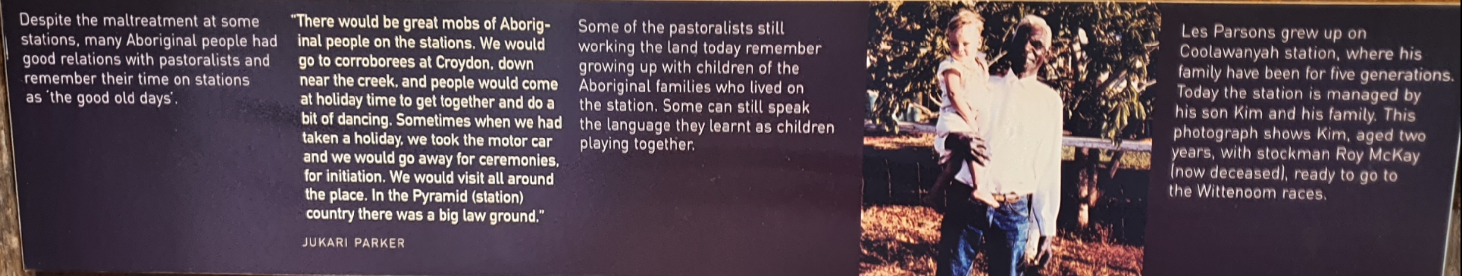
After tucking the Explorer into an available parking spot, we alighted and made the short walk to the Visitors Centre. It was almost closing by the time we arrived. An historical exhibit was on display about the early settlement of this area, the cattle ranches, the unpaid labour of the Aborigines that worked on these ranches, the unforgiven environment in which they worked and the poor condition of life they lived. We had to quickly go through the exhibit as the Visitor Centre was closing its doors. Outside the Visitors Centre is a big signboard welcoming all and explaining about the Warlu Way, which unknowingly is the significant portion of the trip we had taken so far to get here.
The Warlu Way follows the path of the Warlu (the Dreamtime sea serpent) as it traverses North West Australia, the Pilbara and Kimberley regions of Western Australia. It is held by the Aborigines that the mighty Warlu emerged from the sea in times of old and in the process of travelling through the red heartland, it created mountains and waterways covering the over 2480 sq.kms from Exmouth through Karratha, Port Hedland, Broome and Tom Price areas. I see a similarity in the Aboriginal story of creation with that of the Yoruba people who talked about Obatala and the cockerel that created the earth.
Leaving the Visitors Centre, we made haste to arrive at Dales Gorge, the closest of all the tourist attractions in this national park. Closeness is relative though, as getting there was still 11kms away from the centre. The path into the ancient cavernous gorge was down from the rocky cliff on a series of iron stairs with handrail for support. Everywhere we looked was amazing, with the brownish red hue of the mountain surrounding us showing they are iron rich. It was first the sound of the falls but soon we could see the Fortescue Falls below us and we stopped at a section on the steel stairs to take a picture. In doing so, we created a little traffic behind us and two ladies immediately stepped up to help with the picture taking. After taking us some stunningly beautiful pictures, they asked to know where we are from. Nigeria, I said and immediately one of the ladies started singing and dancing QDOT “Gbese, Gbebodi” song. I was pleasantly surprised. Here, in the middle of nowhere is a lady celebrating the artistry talent of Nigeria. I was compelled to ask her where she is from and she said Colombia and that Nigerian songs are very popular there. This chance meeting with the Colombian ladies as we descended into the gorge became one of my best “Proudly Nigerian” moment.
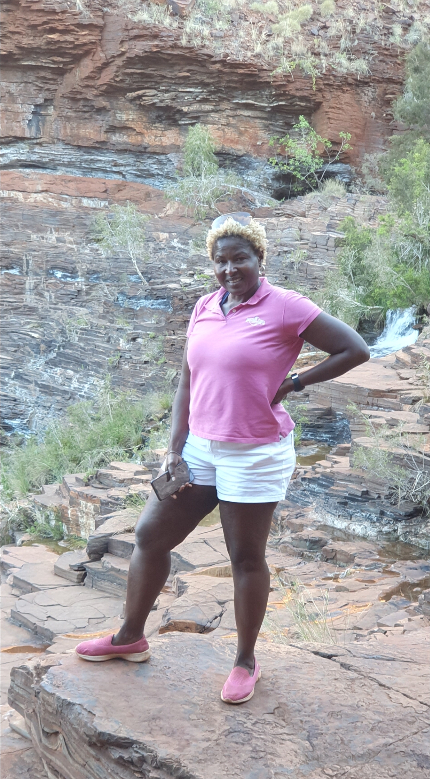
By the time we actually got to the falls with its waters cutting sharply through age old rock structure before splashing down into a pool, the Colombians were already enjoying the therapeutic coolness of the fall. Again, she called, drawing my attention to her dance steps and I did my best to show mine which, unfortunately, were nowhere as good as hers. The Fortescue Falls are not in any scale comparable to the mighty Niagara Falls but the fall which runs over the edge of small jagged rocks, arising from the sheer splendour of the surrounding timeless rocks of the Dale Gorge, is remarkable on its own as a tourist attraction.
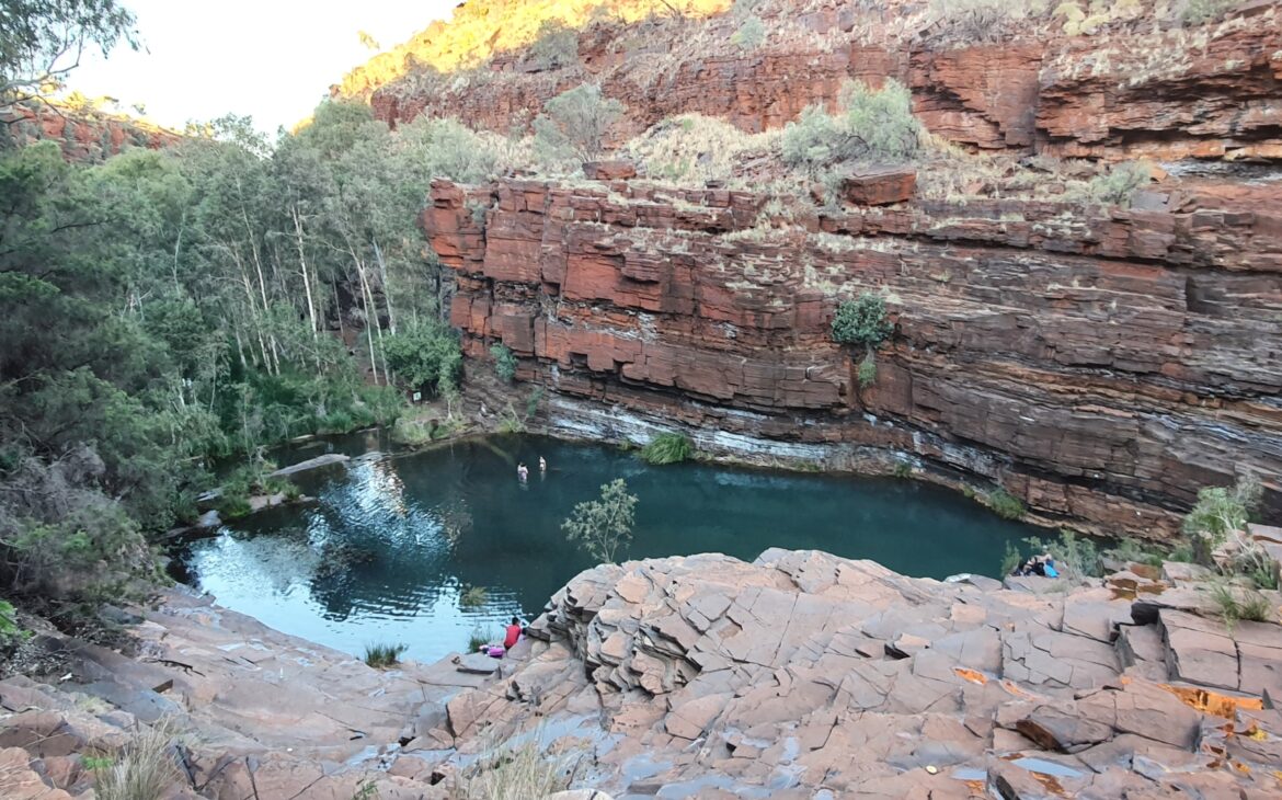
After satisfying ourselves with the beauty of the falls, we left to explore the Fern Pool which was about 300 metres away. The pool’s cooling waters are fed by a natural spring and is surrounded on all sides by lush green ferns. It is a popular swimming spot for most visitors to the park and there were already families enjoying the pool and unwinding in it. Unexpectedly, the water was cold, very cold, and yet everywhere around us was warm. We were thus dissuaded from jumping into it but spent time enjoying the sights and sounds of this wonderfully kept nature’s retreat.

